Tools
Vertex Groups Generate/Update
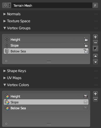
Mirage generates vertex groups to store information about the terrain. These weight groups are also automatically converted into color vertex groups to use in Cycles. You can use the buttons included in the tools panel to update the groups after you have made changes to the terrain.
They can also be used to add vertex groups to other meshes, or purely sculpted terrains.
Export Vertex Group to Image

Exports a specific mirage vertex group to a greyscale image. Values will range from 0 (black) to 1 (white).
The image will contain as many pixels as vertices in the terrain, so the image size will be the square root of the vertex count. For example, a terrain of 65,536 vertices (medium detail) will create vertex group images of 256x256 pixels.
Export Heightmap

Export the terrain as a greyscale image. Each value in this image will represent the height of a specific vertex in the terrain, with 0 (black) being the lowest point of the terrain and 1 (white) the highest.
Heightmaps can be edited in any 2D editor (like GIMP and Krita), and they can be imported into meshes by many 3D editors and applications.
The images are saved as image datablocks in Blender. You can find them by going into the UV/Image Editor and finding the image called “Heightmap”.
You can also choose to split the heightmap into several smaller images. The options range from a 2x2 grid (4 images) up to 32x32 (64 images). When exported these images will be named like “[NAME]_x0_y0” where x0 and y0 are numbers representing the position of the image in the grid.
Note
Mirage doesn’t support generating heightmaps larger than terrains at the moment.
Warning
Note that the image has a fake user but it is not automatically saved! If you don’t pack it or save it to an external file before closing, Blender will lose the contents of the image.
Export terrain as data
Export the terrain as a list of heights.
The exported data is saved as a Text datablock. You can find it by going into the Text Editor and selecting “Terrain_data.py”.
Option |
Description |
|---|---|
List |
A flattened list of heights |
2D List |
A list of rows containing a list of columns which contain the heights |
Encoding |
Description |
|---|---|
Python List |
Saves the list as a simple python list (can also be used for JSON) |
CSV |
Save the list as comma-separated values |
Export distribution layers
Export distribution layer as data or an image (splat map).
Format |
Description |
|---|---|
Python List |
A simple python list of coordinates (can also be used for JSON) |
CSV |
Save the list as comma-separated values |
Splat map |
An image where every white pixel represents an object in the terrain |
Option |
Description |
|---|---|
Layer |
Number of the distribution layer to export |
Export all Layers |
Export all distribution layers in sequence |
Use World Coordinates |
Use world or object coordinates |
Discard Z Axis |
Remove Z axis (height) from coordinates |
Note
The last two options have no effect on splat maps